Ancient Geology
One of the most unique aspects of the Rock Point Area is the abundance of a type of calcium rich rock known as Dunham Dolostone. This dolostone is a type of calcium- and magnesium-rich limestone that was formed over 500 million years ago when the earth's plates looked very different from today. Like all limestones, the Dunham Dolostone was formed from the breakdown and deep burial of the calcium-rich shells of aquatic organisms, many of which were found in shallow coral reefs. Dolostone is easily erodible, and can form caves and underground rivers over time. It also supplies calcium to the soil above, which is an essential nutrient for plants (see Soils for more).
The Champlain Thrust Fault
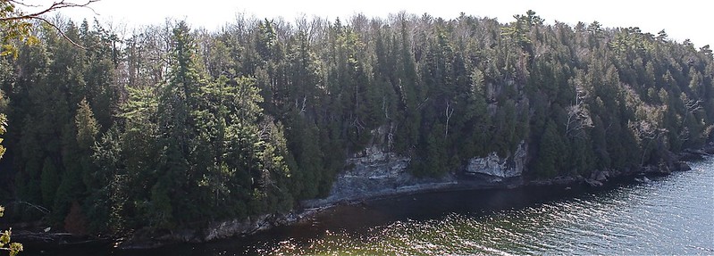
Without a doubt, the Champlain Thrust Fault is the most famous natural feature of the Rock Point landscape, as it is visited by tourists and geologists from all over the world. As shown in the picture below, the thrust fault is an exposure of two different types of bedrock: the sandy-colored Dunham Dolostone or top of the dark grey Iberville Shale.
 |
| Champlain Thrust Fault (Louise Lintilhac) |
The reason this feature is so interesting is because the dolostone rock was formed nearly 40 million years before the shale below it. Normally, as new rock forms, older rocks are buried deeper and deeper; but the shale that was created in the Ordovician era (~460 million years ago) rests below the dolostone formed during the Cambrian era (~500 million years ago). This inversion of the two rock types occurred during a mountain building event known as the Taconic Orogeny, when the land masses we know as Maine and New Hampshire were colliding against present-day Vermont, creating the Green Mountains. The intense heat and pressure caused by the movement occasionally buckled the bedrock, causes slips and fractures that pushed sections of one plate on top of another, as in the case of the Champlain Thrust Fault. While this kind of activity occurs throughout the world, the Champlain Thrust Fault at Rock Point is unique because the exact point of contact of these two rock types is exposed at eye-level (the entire length of the thrust fault extends nearly 200 miles from Canada to the Catskill Mountains).
You can explore a GigaPan image of the Thrust Fault here:
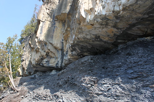 |
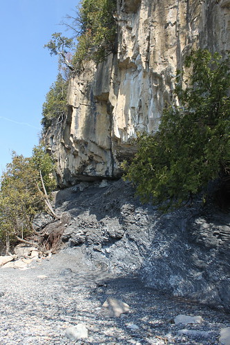
| Champlain Thrust Fault - Contact point of Dunham Doostone above and Iberville Shale below (Louise Lintilhac) |
You can explore a GigaPan image of the Thrust Fault here:
Glaciers and Soils
Long after the formation of the thrust fault, during the ice age known as the Pleistocene around 20,000 years ago, Vermont was covered in a two-mile thick sheet of ice. As the glacier began melting nearly 15,000 years ago, it left behind the sand, gravel, rock, and silt it had scraped away during its movement. With the glacier slowly receding to the north, the meltwater began filling the valley between the Adirondack and Green Mountains, creating a body of water known as Lake Vermont, much larger and higher than present-day Lake Champlain. The rivers began flowing with immense power, depositing sands and silts at their deltas in the same fashion we see today. One of these massive deltas was located where the city of Burlington now stands. This is why so much of the Rock Point Area is composed of coarse sandy soils and sandy loams.
On the spectrum of particle size, soils are classified along a spectrum of three main categories:
CLAY (very fine) ----- SILT (fine) ----- SAND (coarse)
"LOAM" = a mix of all three
These sandy soils keep the forests well-drained and dry for the most part. However, where there are particularly large deposits of silts and clays, it is interesting to note how that influences the vegetation above. When compared to the map of Wetlands at Rock Point, you will notice that the majority of the wetlands occur on top of these poorly-drained soils.
The map below outlines four main areas where the soils are quick different from the common sandy soils found on most of the property. The light pink area is composed of silty loam soils that are only moderately-drained, and the three dark pink areas are composed of silty-clay mixtures that are poorly-drained.
Poorly Drained Soils at Rock Point:
View Soils at Rock Point in a larger map
The pattern in soil moisture becomes obvious: those poorly drained areas tend to also be the places where wetlands have formed, or where the soils are noticeably wetter (and your boots noticeably muddier!):
Wetlands at Rock Point:
Wetlands at Rock Point:
View Wetlands of the Rock Point Area in a larger map